Refer to your Pilots Operating Handbook for specific performance applicability. This guide shall not be used as official aeronautical information and is designed as a reference for exploring and understanding local open spaces that may support an emergency landing. This guide does not indicate a preference or recommendation by Truckee Tahoe Airport for any particular emergency procedures.
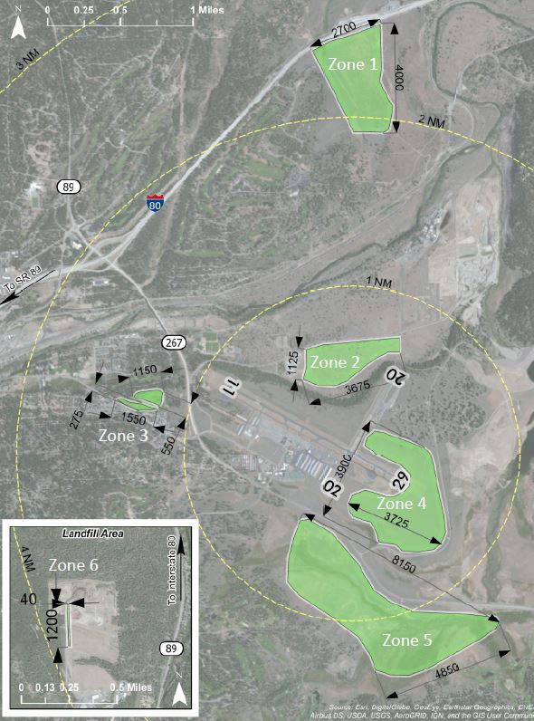
The Old Airport Flats is an open space located two miles to the north when departing Runway 02. If flying runway heading, this area is straight out and slightly to the left. Its dimensions are 4,000' (north to south) by 2,700’ (east to west). It is bordered by Interstate 80 to the north and is bisected northwest to southeast by a 20’ wide dirt road. The surface consists of dirt and sagebrush that is one to three feet tall with very few, scattered trees under ten feet tall. Wildlife is a potential factor in this area.
Zone 1 VideoThe Bus Depot is an open space just to the west of the end of the runway when departing Runway 02. If flying runway heading, this area is directly to the left. There is a drop-off on the north end of the runway and the Bus Depot is level with the bottom of the drop-off, 100’ below the airfield. Its dimensions are 3,675’ (east to west) by 1,125’ (north to south). It is bordered by trees to the north, power lines and a ten-foot wide dirt road to the east, trees and a ten-foot wide dirt road to the south, and a building and parking lot to the west. The surface consists of dirt and sagebrush that is one to three feet tall with scattered trees on the north side of the area. Wildlife and few scattered five-foot tall boulders are potential factors in this area.
Zone 2 VideoThe Ponderosa Golf Course is an area of clearings 0.5 miles to the southwest when departing Runway 29. If flying runway heading, this area is just to the left. It consists of nine fairways separated and lined by trees. The fairways are 700' - 1,200’ (east to west) by 100’ (north to south). Trees border the fairways in all directions. Additional consideration is warranted while the course is open to golfers during the summer months.
Zone 3 VideoThis zone includes the southeast area between the two KTRK runways and wraps around behind Runway 29 to the northeast side. If departing Runway 11, this area surrounds both sides of the end of the runway. When departing Runway 20, this area borders the left side of the runway. Its dimensions are 3,725’ (east to west) by 3,900’ (north to south). It is bordered by Runway 11/29 and trees to the north, a 20’ wide paved road to the east and south, and Runway 02/20 to the west. A 50’ wide section of cleared brush bisects the area east to west on the south side of Runway 29. The surface consists of sagebrush that is one to three feet tall with scattered small boulders. Being near the end of two runways, low-flying aircraft is a factor in this area.
Zone 4 VideoMartis Valley is an open space 0.5 miles to the south when departing Runway 20. If flying runway heading, this area is straight ahead. Its dimensions are 8,150’ (east to west) by 4,850’ (north to south). It is bordered by Highway 267 to the north, power lines and trees to the east, power lines to the south, and trees to the west. Several creeks one to four feet wide are scattered throughout the area and a four-foot tall wire fence bisects it north to south in the western third of the area. The surface consists of sagebrush that is one to three feet tall, several hiking trails and wooden boardwalks, and it is a seasonal marshy wetland. Wildlife is a potential factor in this area.
Zone 5 VideoThe landfill is easily distinguishable from the sky as it’s almost a square mile of clearing near Highway 89. This zone is four miles to the southwest when departing Runway 29. If flying runway heading, this area is to the left. The only usable section of the landfill is a service road on the western boundary. Its dimensions are 1,200’ (north to south) by 40’ (east to west.) The road is paved until the last 400’ where it transitions to dirt on the north end. It is bordered by the landfill facility to the north, a large pit to the east, and trees to the south and west. The road has multiple speed bumps, road signs, frequent trucks and slopes upward heading north.
Zone 6 VideoThe KTRK Safe Haven Initiative is designed as a means of assistance for transient private pilots during times of unsafe flying weather and unforeseen hardship. The program is designed to help pilots and their passengers to attain impromptu, oneoff, overnight housing with an established network of local pilots willing to help a fellow pilot out
Safe Haven Details