toggle navigation
Flight Planning
Pilot Essentials
Airfield Data
Procedures
Seasonal
Noise Abatement
FAQs
FBO
Fuel
Services & Pricing
Food
Transportation
Lodging
FAQs
Reservations
How'd We Do?
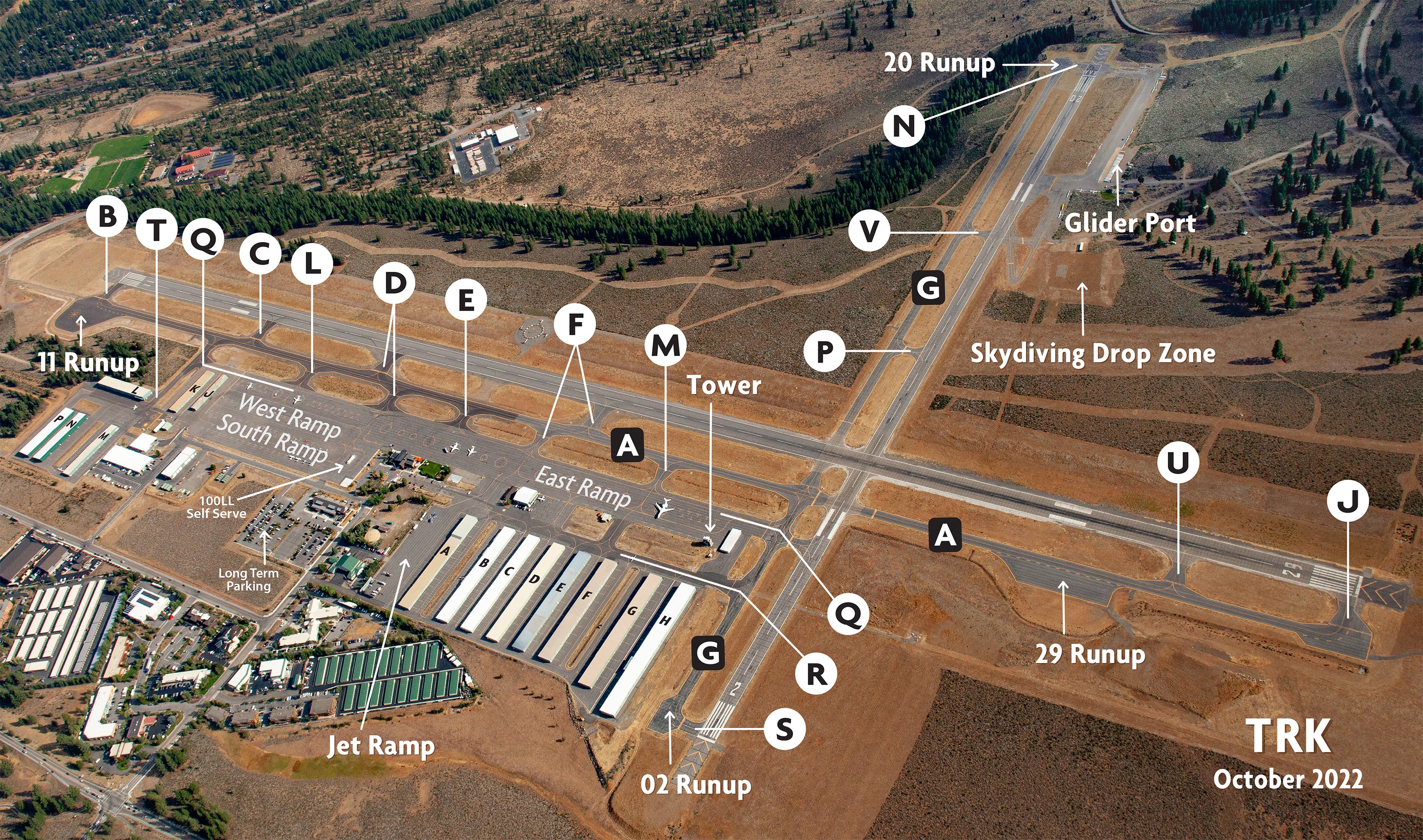
Airfield Data
Jump to
Frequencies
Hours
Runways
KTRK NOTAMS
FREQUENCIES
TOWER/CTAF
120.575
AWOS
118.0
UNICOM-FBO
122.95
GROUND
118.3
*when Tower is in operation
Oakland Center
127.95 Mhz
ATC TOWER HOURS
Summer
05/1 - 09/2, 07:00 - 20:00 local
Fall
09/3 - 09/30, 07:00 - 19:00 local
Winter
10/1 - 03/14, 07:00 - 18:00 local
Spring
03/15 - 04/30, 07:00 - 19:30 local
FUEL HOURS
Full Service
100LL and SAF Jet-A available 7am to 7pm
Self Service
100LL available 7am to 9pm (Summer) 7am to 7pm (Winter)
Runways
Runway 11/29
Runway 11
Runway 29
Runway 02/20
Runway 02
Runway 20
Dimensions
7,000 x 100 ft. / 2,134 x 30 m
Surface
Asphalt/grooved. In good condition.
Weight bearing capacity
Single wheel: 50,000 lbs, Double wheel: 80,000 lbs.
Anything over 50/80 on 11/29 needs a PPR (Prior Permission Request)
Runway Edge Lights
Medium intensity
Latitude
39-19.490400N
Longitude
120-09.163867W
Elevation
5897.1 ft.
Gradient
0.1
Traffic pattern
left
Runway heading
104 magnetic, 120 true
Markings
basic, in fair condition
Runway end identifier lights
yes on request before 9pm (REILS)
Touchdown point
yes, no lights
Obstructions
55 ft. tree, 1470 ft. from runway, 23:1 slope to clear
Latitude
39-18.914167N
Longitude
120-07.878400W
Elevation
5888.9 ft.
Gradient
0.1
Traffic pattern
left
Runway heading
284 magnetic, 300 true
Markings
basic, in good condition
Runway end identifier lights
no
Touchdown point
yes, no lights
Obstructions
none
Dimensions
4,650 x 75 ft. / 1,417 x 23 m
Surface
asphalt, in good condition
Weight bearing capacity
Single wheel: 35,000 lbs, Double wheel: 50,000 lbs
Runway edge lights
medium intensity
Longitude
120-08.398317W
Elevation
5886.3 ft.
Gradient
0.2
Traffic pattern
left
Runway heading
014 magnetic, 030 true
Displaced threshold
no
Markings
basic, in fair condition
Visual slope indicator
2-box VASI on left (3.50 degrees glide path)
Runway end identifier lights
no
Touchdown point
yes, no lights
Obstructions
225 ft. tree, 4800 ft. from runway, 20:1 slope to clear
RWY 1 APCH RATIO 20:1
Latitude
39-19.534467N
Longitude
120-07.905583W
Elevation
5886.5 ft.
Gradient
0.2
Traffic pattern
right
Runway heading
194 magnetic, 210 true
Displaced threshold
115 ft.
RY 19 DSPLCD THLD NOT LGTD. RY 19 EDGE LGTS BEGIN 400 FT FM EOR.
Markings
basic, in fair condition
Runway end identifier lights
no
Touchdown point
yes, no lights
Obstructions
none
APCH RATIO TO DSPLCD THLD 50:1.
Frequencies
TOWER/CTAF
120.575
Mhz / AWOSf
118.0
Mhz / UNICOM-FBO
122.95
Mhz / GROUND
118.3
Oakland Center
127.95
*
*
When Tower is in operation.
Tower ATC Hours
Fall & Winter
10/1/21 - 03/31/22, 07:00 - 18:00
Spring
04/1/22 - 05/31/22, 07:00 - 19:00
Summer
06/1/22 - 09/30/22, 07:00 - 20:00
Fall & Winter
10/1/22 - 03/31/23, 07:00 - 18:00
All times local.